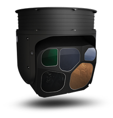
Mapping Oregon Wildfires with Teledyne FLIR Star SAFIRE 380-HDc

Over the past decade, robust wildfire response and prevention has become increasingly vital in the American West, as fire seasons have increased in duration and intensity. The Oregon Department of Forestry is leading the nation with their fire-spotting and mapping programs, powered by the Teledyne FLIR Star SAFIRE 380-HDc.
The current fire-mapping program began in 2017, when the Teledyne FLIR PC-12 came out to assist Oregon State firefighters in battling the Horse Prairie Fire in the southwestern area of the state, not far from Umpqua National Forest. Using the Star SAFIRE 380, the Teledyne FLIR Flight Department and Applications Engineering were able to guide the response using real-time images to the firefighting team with the downlink, as well as on a big screen for the Incident Commander to see what was happening from above. This was the first time that the Agency had gotten to experience the system’s capabilities hands-on, and the results sent the Oregon Department of Forestry down a multi-year path to obtain their system and begin their leading fire-mapping program.

2023 was the 4th fire season where the department was able to run the system, which involves scouting missions at night using both the infrared camera and night vision goggles. This unique approach that Oregon has pioneered is far more effective than flying similar missions during the morning and daytime hours, when firefighters must be on the lookout for signs of fire themselves (such as flames or smoke), which are usually apparent after the fire has grown to a dangerous level. With the EO/IR sensor scanning the entire nighttime landscape, the Star SAFIRE 380- can detect remote hotspots in trees or brush before the fire or any other visible sign even breaks out, all within a much wider line-of-sight.
__________________________________________________________________________________________________
As a result, a staggering 95% of new Oregon fires detected in 2023 were mapped and contained before they spread.
__________________________________________________________________________________________________
“When you can find those fires when they’re less than a quarter acre in size, sometimes the size of a card table, then we can give the ground crews imagery and they can go out at first light,” said Cole Lindsay, Northwest Oregon Area Aviation Coordinator with the Oregon Department of Forestry. “Sometimes they can’t even see it with their eyes, but they can find it on the map.” If similar spots were reported in the middle of the day, by the time they were seen by human eyes, by the next afternoon it could be 1500 acres.”

Incorporating Augmented Reality and laser pointing has also been a boon to saving time and resources, as it allows for remote and hard-to-determine locations to be communicated much faster. That speed of response and breadth of coverage means less fuel burned circling in the sky, and a more effective use of invaluable firefighter time driving out to respond.
"The 380-HDc system really works, and we keep getting reminded that if any of these fires catch the next day, thousands and thousands of acres, and millions of dollars of damage could be done," he added. "Every tiny fire we find is a huge benefit to the state."

As a result, several other states have come out to train on fire-mapping with the Oregon team, aiming to repeat the success of this offensive approach.
"Finding and keeping fires small is our classic motto," Cole added. "The Teledyne FLIR camera system was never initially intended for finding fires, but they've worked very closely to dial it in."
See below for the Oregon Department of Forestry's video on their fire-mapping efforts, and hats off to the Surveillance team for their innovation and flexibility in supporting this program.


